ANRA Technologies Launches VISTA Airspace Awareness Application for Drone Operators
| Shelf | Airlines & Routes |
|---|---|
| Date in | |
| Readers | 800 |
ANRA Technologies has introduced the Visual Interface for Shared Traffic Awareness (VISTA), a new application designed to give drone operators The post ANRA Technologies Launches VISTA Airspace Awaren...
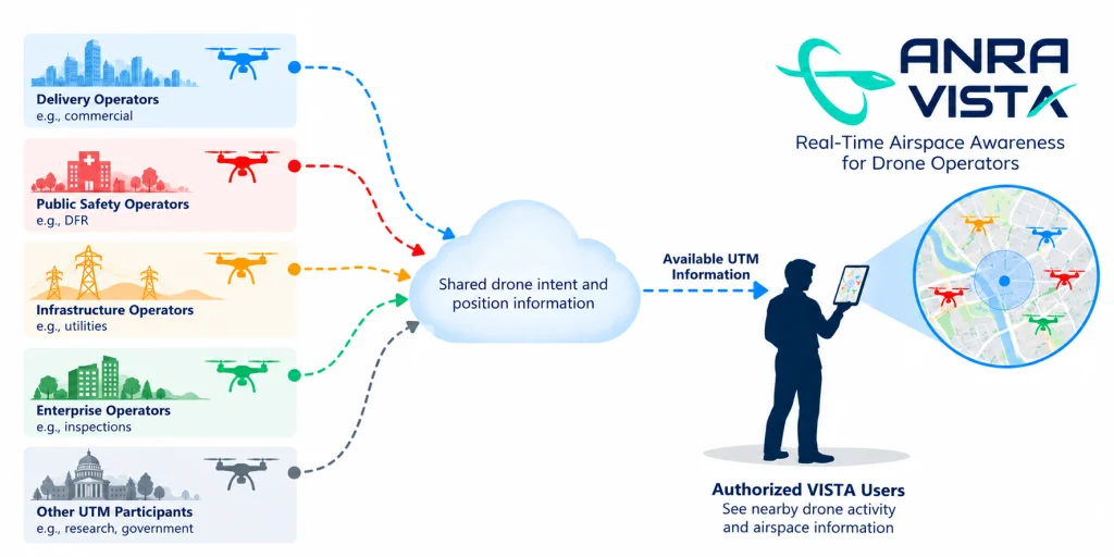
ANRA Technologies has introduced the Visual Interface for Shared Traffic Awareness (VISTA), a new application designed to give drone operators greater visibility of nearby uncrewed aircraft activity by displaying available flight-intent and position data from Uncrewed Aircraft System Traffic Management (UTM) services.
Announced on 14 October, VISTA is aimed at public safety agencies, commercial drone operators and organisations conducting activities such as infrastructure inspection and drone delivery. The application displays available information about nearby drone flight intentions and reported positions in a visual format.
As drone operations expand, aircraft operated by different organisations are increasingly sharing low-altitude airspace. ANRA says operators may have limited visibility of nearby flights, particularly when those missions are managed by separate organisations or systems. VISTA is designed to help operators assess activity around planned missions and make better-informed operational decisions.
VISTA does not connect aircraft to UTM services or submit flight plans, instead functioning as a recieve-only platform. It provides an additional source of situational awareness without requiring operators to replace their existing aircraft or flight applications.
ANRA says that VISTA provides several capabilities for organizations operating in shared airspace, such as:
- Viewing available information about drone flight intentions and reported positions around a mission area for greater flight awareness.
- Displaying shared operational data in a format that pilots and supporting teams can quickly understand and respond to.
- Checking relevant drone activity before launch, and maintaining awareness of other drones throughout a flight.
- Accessing shared airspace information without replacing aircraft, flight applications or existing operational systems — meaning less disruption to existing infrastructures that choose to make use of VISTA.
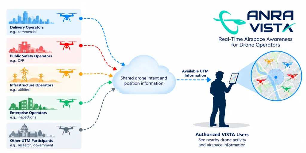
Potential users include emergency services running Drone as First Responder (DFR) programmes, where aircraft may be deployed near incident scenes, as well as utilities and infrastructure operators conducting inspections and maintenance. In these environments, awareness of other drone activity can be relevant to mission planning and flight safety.
VISTA builds on ANRA’s existing UTM and airspace visualisation work. The company reports that its UTM platform supports approximately one drone mission every 15 seconds during daytime operations. It also says more than 20 organisations, primarily DFR programmes, already use its visualisation capability to monitor drone activity in their operating areas.
The application relies on information available through the UTM ecosystem, meaning its usefulness depends on the data shared and reported by participating services. It is intended to complement existing operational procedures rather than replace them, with data from previous uses potentially feeding back into the ecosystem to further refine the system.
The post ANRA Technologies Launches VISTA Airspace Awareness Application for Drone Operators appeared first on eVTOL Insights.The post ANRA Technologies Launches VISTA Airspace Awareness Application for Drone Operators appeared first on eVTOL Insights.